
Learn How a Wobbly Polar Vortex Can Bring Extreme Cold
In recent years, we’ve heard more and more talk about the polar vortex, which is a fast-flowing jet stream of air that circles the North Pole in the upper parts of the stratosphere about 20 miles above Earth’s surface. What does it do, exactly? And what does it mean for us when it stops flowing as it should?
The Polar Vortex Paradox
When the polar vortex is strong, it keeps most of the frigid Arctic air in the polar region, resulting in mild winter temperatures in the middle latitudes of the eastern United States and in northern Europe and Asia. But when the polar vortex weakens, the once-trapped cold air can meander and push southward, bringing polar temperatures and extreme winter weather into the United States. (The changing back and forth of the polar vortex’s strength is referred to as the Arctic oscillation.)
Under normal winter conditions, the polar vortex is strong enough to keep the coldest air bottled up in the north, but in recent winters, we have seen exceptionally mild temperatures at times in the far north. It is that unusual warming which causes the jet stream to wobble and eventually buckle, bringing the cold, Arctic weather into the United States.
So, although it may sound counterintuitive, freezing temperatures in the Lower 48 could be caused by warmer weather in the far northern regions of Earth.
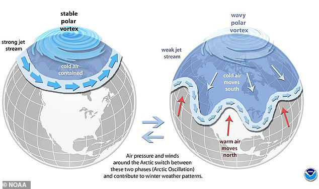
Figure 1. In the weak phase of the Arctic oscillation, the Arctic jet stream weakens and “wobbles,” allowing the polar vortex to descend southward.
A Wobbly Polar Vortex
Occasionally, warmer temperatures can cause the polar vortex to get “wobbly.” The final straw may be rapid warming that occurs in the stratosphere, some 20 miles above Earth’s surface. It’s like a hacksaw of warm air cutting right through the cold air and releasing it, allowing it to move away from its normal home in the far north.
This creates different vortices that are liable to wobble southward to different regions, like the U.S. and Europe at the same time, which happened in mid-January in 2019 and brought extremely cold temperatures.
What exactly triggers these warming events high above the polar vortex remains unknown, but one theory that is gaining prominence blames the rapid diminishing of Arctic sea ice. With the Arctic warming more than twice as fast as the rest of the globe, the amount of Arctic sea ice cover is plummeting.
As a result, recent climate research suggests that without the ice cover to act as a blanket, more heat escapes from the oceans, warming the air above them. Ultimately, researchers found that this relatively warmer air interacts with and weakens the winds over the arctic, allowing frigid polar air to more easily escape to southerly places like Chicago and Boston.
What Does it All Mean?
It’s important to note, however, that these cold blasts do not mean that Earth is cooling. In fact, it is the warming of the planet that is causing these cold disruptions, displacing Arctic air that would otherwise stay put over the Arctic. Despite these cold periods, most of Earth still experiences warmer-than-average temperatures in any given month, and some of the warmest years on record for Earth as a whole have come in the past 10 years.


ADVERTISEMENT
Who or what verifies your data? Also who proof reads this stuff?
With the idea of quantity and the fact alcohol,simoly won't get the job done we have educators and all other types of fields if workers that understand BATTERY POWERED AS FAR AS LOCATION THE ARTIC WATERS. These times of warming were predictable and we gave to understand that GOD gives us power that is monitored and discussed to keep the polar region at a legal of moderate weather. So with banana cream boat guy its understanding to freeze the waters because if you examine the waters can be frozen but the battery packs have to be measured to and idealistic that they will stay frozen compared to the closeness of the sunand the fact ice water and drinking water will help out with the legal ideas that can bring a heated world but is moderated. We are told the world is supposed to be as the tropics and it will just take the right measurement and battery powered remotes with withstanding antennas to measure and basically refreeze the polar region to its back to normal weather pattern as the collegiate and professors are on it thank you for letting me add my two cents have a lovely day,sir
In this part of the country we have pretty good weather records that go back about 150 years. If the earth were only 15,000 years old, that would be a 1% sample. Pretty small sample to try to establish what is "normal."
Scientists tell us there have been several ice ages over thousands of years with periods of warming between. I don't suppose our ancestors were sitting around a campfire banging their clubs on the ground asking, "How have we caused this?"
People were of insignificant influence on the earth back then. Can't possibly compare the 2 eras of human influence
Other than some reversals, ice has been melting back ever since the ice age about 4500 years ago. As it melts, more dark earth is exposed to absorb heat from the sun, so the warming accelerates. Warming is due to solar activity. It's not man-made. CO2 is rather insignificant. As for the fluctuations, warming comes first; then the increased CO2 because the warmer water releases it to the atmosphere.
Comments