What can we look forward to weatherwise over the next several months? Almanac meteorologist Michael Steinberg explains a few of the factors that go into our forecasts and predicts how well our forecast will hold up.
Advertisement
(Haven’t had a chance to read our winter predictions yet? Find our 2020 Winter Forecast here!)
Teleconnections Tell the Future
As always at the Almanac, first we look to the Sun, where we find that Solar Cycle 24, the smallest in more than 100 years and possibly the smallest since the Dalton Minimum in the early 1800s, is very close to its end. Nascent Cycle 25 is expected to also bring very low solar activity. Low levels of solar activity have historically been associated with cooler temperatures, on average, across Earth, so ordinarily this would point to a cold winter across most of the United States and Canada.
However, due to other factors, recent winters have been on the mild side despite low solar activity, so we also need to look to teleconnections as the other primary factor to consider as we look into the future. Teleconnections are patterns in the atmosphere that typically persist from weeks to years and influence temperatures, precipitation, storm tracks, and jet stream over large areas.
Think of a teleconnection as being like construction on an urban highway—it may impact the traffic flow for months (much as a teleconnection impacts the flow of the atmosphere), controlling the traffic flow completely and causing it to back up for miles during rush hour (much as a teleconnection can lead to a series of snowstorms), while at night causing traffic to slow down only through the construction zone (much as a teleconnection may not control the weather continuously, with dry periods between the storms that it brings).
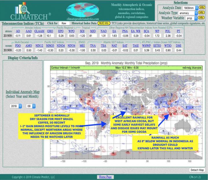
There are many teleconnections, the most well-known 32 of which are listed at the top of Figure 1, below. This table and map are provided courtesy of Jim Roemer of Climatech, who can be reached at bestweatherroemer@gmail.com for more information.

Figure 1: Global teleconnection indices from early fall 2019. Graphic courtesy of Jim Roemer of Climatech.
How Do Teleconnections Factor Into Our Forecast?
We strongly considered the expected teleconnections when we made our forecast for the 2020 Old Farmer’s Almanac nearly a year ago, but our experience has been that forecasts of teleconnections are more accurate as we get closer to the actual forecast period.
Back then, we felt that important factors in the coming weather patterns would include a moderate El Niño, the Atlantic Multidecadal Oscillation (AMO) in a continued warm phase, the North Atlantic Oscillation (NAO) in a neutral to positive phase, and the Pacific Decadal Oscillation (PDO) in the early stages of its warm cycle.
When we now take more current observations into consideration, we come to believe that we will still have the previously forecast El Niño, but that it will be a variant known as an El Niño Modoki. Modoki is a Japanese word meaning “similar, but different,” and here it is used to describe an El Niño in which ocean temperatures are warmer than normal in the central equatorial Pacific region instead of the eastern equatorial Pacific region, which is where the warmer waters associated with the “traditional” El Niño are usually found.
This is an important difference because it drives different weather patterns across North America. The most significant differences are that (1) while a traditional El Niño usually brings rainy weather to California, an El Niño Modoki usually brings dry weather, and (2) temperatures are usually warmer in the El Niño Modoki than in a traditional El Niño in the eastern and western United States and Canada and colder in central sections. Even though we were forecasting an El Niño, we had previously forecast dry weather across much of California and the Gulf of Mexico regions—weather more associated with the Modoki variety than the traditional one.

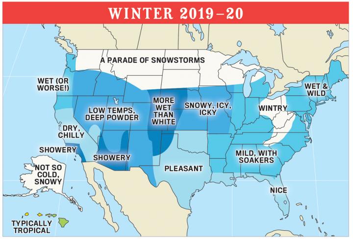
Winter predictions for the United States from The Old Farmer’s Almanac. Read the full forecast here.
Thus, our forecast largely aligns with the current projection of an El Niño Modoki, except that we foresaw somewhat higher temperatures in much of Canada and the central United States than may appear to now be the case.
Our forecasts for the Atlantic Multidecadal Oscillation (AMO), the North Atlantic Oscillation (NAO), and the Pacific Decadal Oscillation (PDO) either remain in line with current projections or are not sufficiently different to cause our original winter forecast to change.
One other teleconnection that is important with regard to this winter’s weather is the Antarctic Oscillation Index (AAO). This had been positive, but record stratospheric warming over Antarctica means that the AAO should trend toward negative.
A negative AAO is typically associated with colder temperatures and abovenormal snowfall across North America, especially in the mid- to later stages of the season. Thus while we do expect that temperatures overall will be above normal, we also see some very cold periods ahead in January and February.

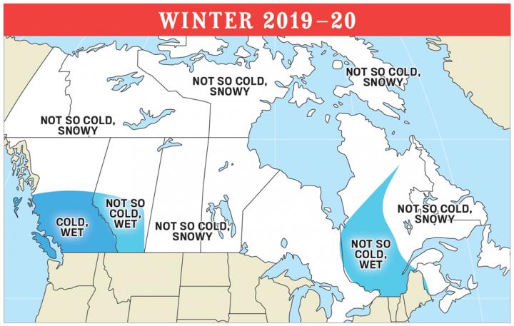
Winter predictions for Canada from The Old Farmer’s Almanac. Read the full forecast here.
The other main factor to consider in the winter forecast has been the recent trend of global average temperatures to be on the increase, especially in the northern United States and central and northern Canada. This is also an important consideration in our winter forecast.
In summary, we can say that the latest data on sunspots and teleconnections cause our forecasts for the upcoming winter (Figures 2 and 3) to change very little. Perhaps the most significant update is that we now expect a higher chance of above-normal snowfall from the mid-Atlantic region into New England, with a powerful Nor’easter or two a distinct possibility in the latter half of winter.
More Weather from The Old Farmer’s Almanac
Interested in learning more? See more articles about how we predict the weather.
For our detailed long-range weather predictions, pick up a copy of the 2020 Old Farmer’s Almanac! Here’s where to find the 2020 edition near you.

Comments